Data Model - Referential
Base classes
Locations (on land or at sea)
Gear classification
Commercial and scientific species
Collected parameters (PMFM)
Regulation (Corpus, Fisheries and minimum size allowed)
Spatial items
Transcribing
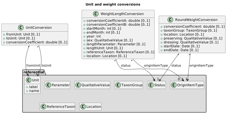
Unit and weight conversions
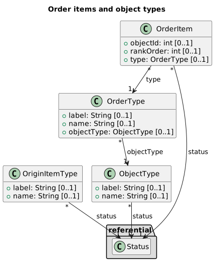
Orders and object types
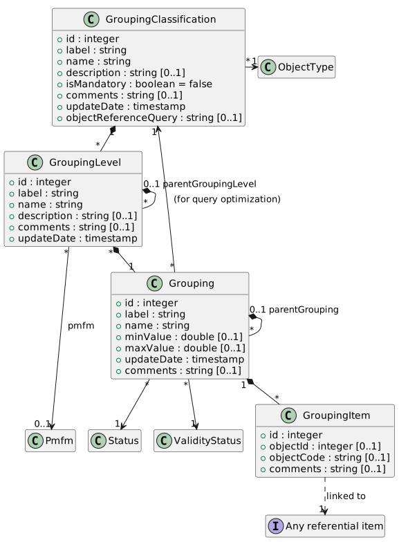
Grouping
Details
Base classes
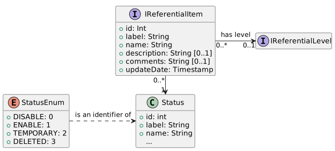
Each referential entity item have a numerical id as identifier, a unique label (for code), a name and a full description.
Referential lists share a common lifecycle: Status (enabled, disabled, temporary)
controls the visibility of items, and ValidityStatus their validity period.
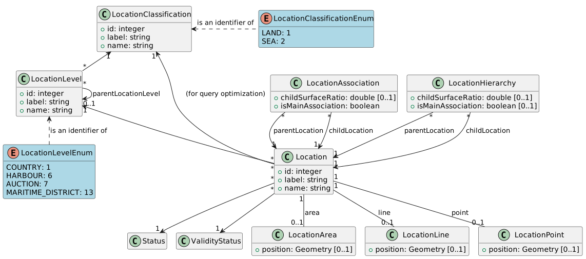
Locations
A location can be:
- a territorial location (e.g. Country, harbour, auction...)
- a fishing area, on any administrative spatial unit at sea (e.g. FAO area, ICES division or sub-division, CGPM..)
A location can have a spatial geometry (area, line, or point) that can be used by SUMARiS GIS capabilities.
Locations are organized by LocationClassification (e.g. administrative vs. marine areas)
and LocationLevel (e.g. Country, Harbour, FAO division). Specialized tables store the geometry
of a location: LocationPoint, LocationLine and LocationArea.
LocationHierarchy and LocationAssociation link a location to its parents or neighbouring locations.
Gear
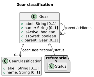
A gear is fishing gear or a scientific gear, used by vessels during a trip. Gear code comes from common referential (e.g. FAO gear code), but can be extended with other gear codification (like national gear codes, scientific cruise codication).
Gears belong to a gear classification (GearClassification, e.g. FAO or national) and can form parent/children hierarchies.
Vessel types (VesselType) and gear classifications are referential lists organized the same way.
Species
Commercial species are call "Taxon Group" in the data model. FAO ASFIS code are used, but can be extends with national codes.
Scientific species are called "Taxon" in the data model.
- For now, codes comes from French RefTax database, or any other national codes;
- A working group (E-IS, Ifremer, MNHN, Sandre) will develop (2020) a Proof of Concept (PoC) to synchronize codes from WoRMS, using Ontologies Web Language (OWL) and the RDF format.
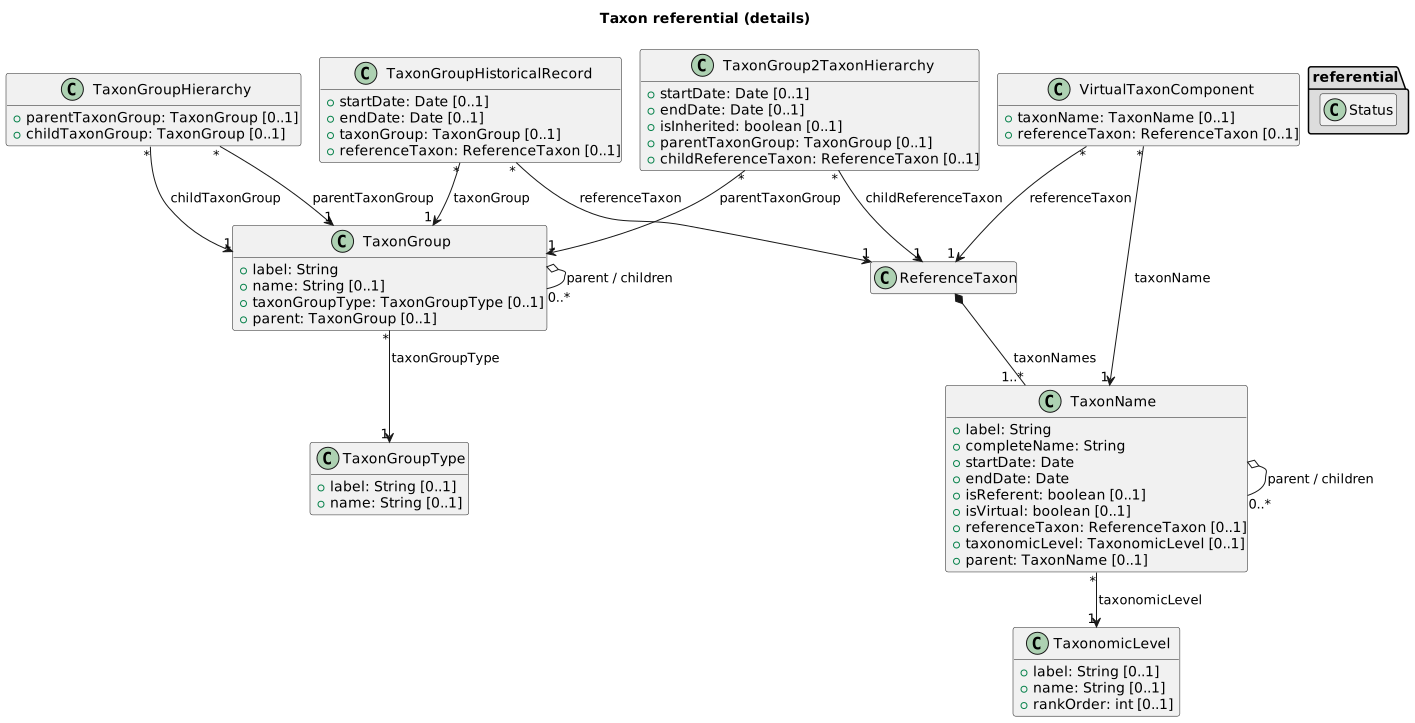
TaxonGroup hierarchies, taxon group types and their historical records; scientific species
(TaxonName, ReferenceTaxon) are organized by TaxonomicLevel, with virtual taxon components.
A TaxonGroup (commercial species) is typed by a TaxonGroupType;
TaxonGroupHistoricalRecord tracks the historical labels of a taxon group,
and VirtualTaxonComponent composes virtual taxon groups.
TaxonGroupHierarchy and TaxonGroup2TaxonHierarchy store parent/children
hierarchies between taxon groups (technical tables used by referential synchronization).
Collected parameters (PMFM)
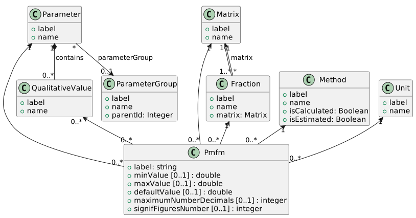
a Pmfm (PMFM) is an association of:
- a Parameter: what is collected (e.g. a distance, a weight...);
- A parameter has a unique type : numerical, alphanumerical, boolean, qualitative values;
- A parameter can define min and max values;
- a Matrix: what is measured;
- a Fraction: a part of the matrix;
- a Method: how to get the measure value;
- a Unit (e.g meters, kilograms...)
This class allows to define any kind of measure type, with the precision expected by all scientific purposes.
Parameters are grouped into a ParameterGroup; a numerical parameter can use qualitative values
(QualitativeValue).
Regulation
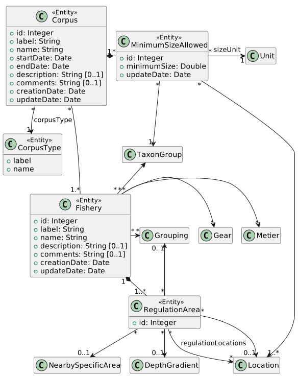
A Metier is a fishing activity, i.e. the combination of a gear and a target taxon group.
A Fishery groups metiers by fishery; RegulationArea defines regulated areas;
MinimumSizeAllowed stores the legal minimum size per species and area; CorpusType
types the regulation corpus. SaleType qualifies the type of a sale (e.g. bulk, box).
Spatial items
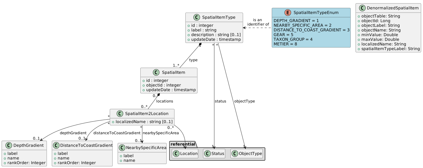
Spatial items enables the translation into the local language of reference lists (species, metier, gear, etc.). It also allows, using the user expertise area, to customize these lists to display only the elements relevant to the user's region.
Spatial items (SpatialItem) are alternative spatial representations (e.g. GIS imports),
typed by SpatialItemType and linked to locations through SpatialItem2Location;
DenormalizedSpatialItem is a flat, pre-computed copy used for fast reporting.
Transcribing
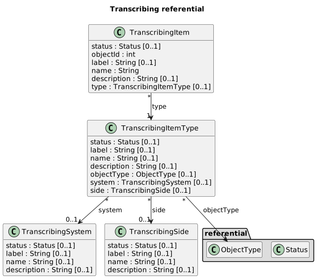
TranscribingItem maps an external system's identifier (or label) to a SUMARiS object,
through transcribing item types, systems and sides:
TranscribingSystem (the external system, e.g. a national database), TranscribingItemType
(the kind of external code) and TranscribingSide (where the mapping applies).
Unit and weight conversions
Conversion coefficients between units, length/weight and round weight conversions,
possibly restricted by species, location, preservation or dressing.
Conversions are typed: UnitConversion (generic unit conversion), WeightLengthConversion
(length/weight) and RoundWeightConversion (live weight conversions).
Orders and object types
OrderItem attaches a rank to objects of a given type (via OrderType and ObjectType);
OriginItemType qualifies the origin of conversions and other typed items.
Grouping
Grouping entities (Grouping, GroupingLevel, GroupingClassification, GroupingItem)
allow to regroup data rows (e.g. by fleet, metier or survey) using a configurable
hierarchy of levels and classification.
Environmental gradients
Environment characteristics observed around a fishing activity are stored as gradients:
DepthGradient (bathymetry) and DistanceToCoastGradient (distance to shore), both in meters.